|
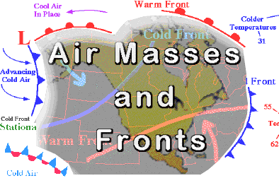
What is an Air Mass?
An air mass is a large body of air that has similar temperature and moisture properties throughout. The best source regions
for air masses are large flat areas where air can be stagnant long enough to take on the characteristics of the surface below.
Maritime tropical air masses (mT), for example, develop over the subtropical oceans and transport heat and moisture northward
into the U.S.. In contrast, continental polar air masses (cP), which originate over the northern plains of Canada, transport
colder and drier air southward.
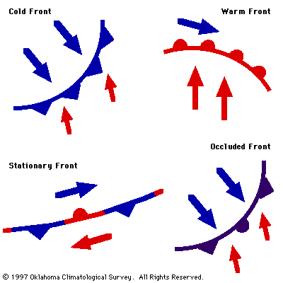
What are the Four Types of Fronts?
Cold front- a front in which cold air is replacing warm air at the surface.
1.Cold fronts tend to move faster than all other types of fronts.
2.Cold fronts tend to be associated with the most violent weather among all types of fronts.
3.Cold fronts tend to move the farthest while maintaining their intensity.
Warm front- a front in which warm air replaces cooler air at the surface.
1.Warm fronts tend to move slowly.
2.Warm fronts are typically less violent than cold fronts.
3.Although they can trigger thunderstorms, warm fronts are more likely to be associated with large regions of gentle ascent
(stratiform clouds and light to moderate continuous rain).
Stationary front- a front that does not move or barely moves.
1.Stationary fronts behave like warm fronts, but are more quiescent.
2.Many times the winds on both sides of a stationary front are parallel to the front.
3.Typically stationary fronts form when polar air masses are modified significantly so as to lose their character (e.g.,
cold fronts which stall).
Occluded fronts are indicative of mature storm systems (i.e., those about to dissipate).
1.The most common type of occlusion in North America is called a cold-front occlusion and it occurs when the cold front
forces itself under the warm front.
The weather ahead of the cold occlusion is similar to that of a warm front while that along and behind the cold occlusion
is similar to that of a cold front.
|
 |
What are The Four Types of Air Masses that Affect Our Weather?
Maritime Tropical Air Masses
warm temperatures and rich in moisture
Maritime tropical air masses originate over the warm waters of the tropics and Gulf of Mexico, where heat and moisture
are transferred to the overlying air from the waters below. The northward movement of tropical air masses transports warm
moist air into the United States, increasing the potential for precipitation.
Maritime polar air masses- build up over the northern oceans. These are not as cold as continental air masses but are
more humid. The chilly, damp weather that is typical of the Pacific northwest is a result of these air masses
Continental Polar Air Masses
cold temperatures and little moisture
Those who live in northern portions of the United States expect cold weather during the winter months. These conditions
usually result from the invasion of cold arctic air masses that originate from the snow covered regions of northern Canada.
Because of the long winter nights and strong radiational cooling found in these regions, the overlying air becomes very cold
and very stable. The longer this process continues, the colder the developing air mass becomes, until changing weather patterns
transport the arctic air mass southward.
Continental tropical air masses- form over the deserts of the Southwest and Mexico. These air masses give the Southwest
its warm, dry climate, but they do not move into other parts of the United States as often as the maritime tropical air masses
or polar air masses.
|